The Characteristics of the Austrian Cadastre
Dipl.-Ing. Dr. Dr.h.c.
Institute of Geomatics, BOKU University, Vienna
mansberger@boku.ac.atDipl.-Ing. (retired since March 1, 2024)
BEV – Federal Office for Metrology and Surveying, Vienna
Julius.ernst@aon.atDipl.-Ing. Dr. (retired since April 1, 2023)
BEV– Federal Office for Metrology and Surveying, Vienna
geomugg@gmx.atPriv.Doz. Dipl.-Ing. Dr.
Department for Geodesy and Geoinformation, TU Wien
gerhard.navratil@geo.tuwien.ac.atUniv.Doz. Dipl.-Ing. Dr.Iur.
Department for Geodesy and Geoinformation, TU Wien
ch.twaroch@live.atPublisert 27.08.2024, Kart og Plan 2024/2, Årgang 117, side 182-190
Introduction
Land administration is the bundle of rules documenting land tenure/land ownership in relation to a certain area. It includes the tools for assessing, documenting, and mapping this information (Mattsson and Mansberger 2017). With it, the state contributes to the functioning of the land market by providing security, transparency and symmetric information about land, land rights, land value, land use, and land development. Such a framework facilitates efficient resource allocation, i.e. the optimal distribution of the finite resource that is land.
Cadastre and land register are the two main components of a state land administration system (LAS) for the administration of boundaries, parcels and related rights and obligations. The Austrian LAS ensures protection and equity for both owners and the broader society, encompassing private individuals and public entities, taxpayers and tax collectors. Furthermore, it underpins the trust and legitimacy of a modern state, serving as a critical foundation for its governance.
The current and well-functioning Austrian land administration system has been based on scientific findings since its beginnings in 1817, and is continuously being improved (Hernik et al. 2020). This article focuses on the geometric and physical aspects of LAS, the cadastre. It emphasises the features that have contributed to the two-hundred-year success story of the Austrian cadastre (Ernst et al. 2017, Ernst et al. 2019, Bundesamt für Eich- und Vermessungswesen 2023).
Overview of the Austrian Land Administration System
History of the Austrian Cadastre
After the Napoleonic wars, the economic situation of the Austrian-Hungarian monarchy was difficult. To consolidate public finances, a new system for collecting property tax on land was introduced in 1817, considering the potential net income from the existing soil quality of the properties at this time. If the landowners subsequently carried out measures to improve the soil quality, this had no effect on the originally determined tax.
A decision from 1869 that the cadastral data should be updated periodically was replaced by the concept of continuous updates in 1883. In 1871 the cadastre was linked to the land register, documenting the rights on land (Mansberger et al. 2016, Twaroch et al. 2016).
Since their inception, the cadastre and land register have evolved into a comprehensive LAS, adapting to shifts in socio-political demands, updates in the legal framework, and advancements in technology (see Figure 1). Emerging technologies were adopted to support the administration and improve services. Examples are punch cards, geographic information systems, or public web access. As early as the 1980s, a common database for cadastre and land register was developed to prevent contradictions between these parts of the system (Muggenhuber et al. 2017).
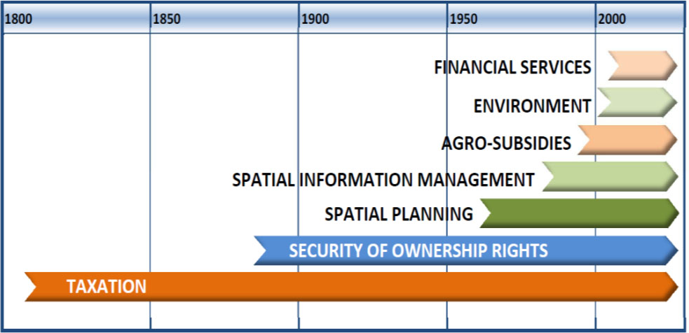
Figure 1.
Evolution of Aims of the Austrian Cadastre (Source: Muggenhuber et al. 2011).
Austrian Land Administration System
In Austria it is mandatory to register any real estate in the national LAS, consisting of the cadastre and the land register. The documentation of boundaries and some other physical information of land parcels is provided through 41 cadastral offices, which are coordinated by the Federal Office for Metrology and Surveying (BEV). The documentation of land rights is carried out by 114 land register offices located at Austrian district courts under the Federal Ministry of Justice. Both the cadastral offices and the land register offices are part of the public administration. Notaries support the land register authorities by issuing deeds for land right changes, while the licensed surveyors support the cadastral authorities in the subdivision and surveying of land. The cadastre and land register are completely independent in terms of organization, personnel and finances. District courts and cadastral offices maintain the specific information in two separate databases for the cadastre and the land register, which are, however linked to each other via the parcel number and are synchronized on a daily basis (see Figure 2).
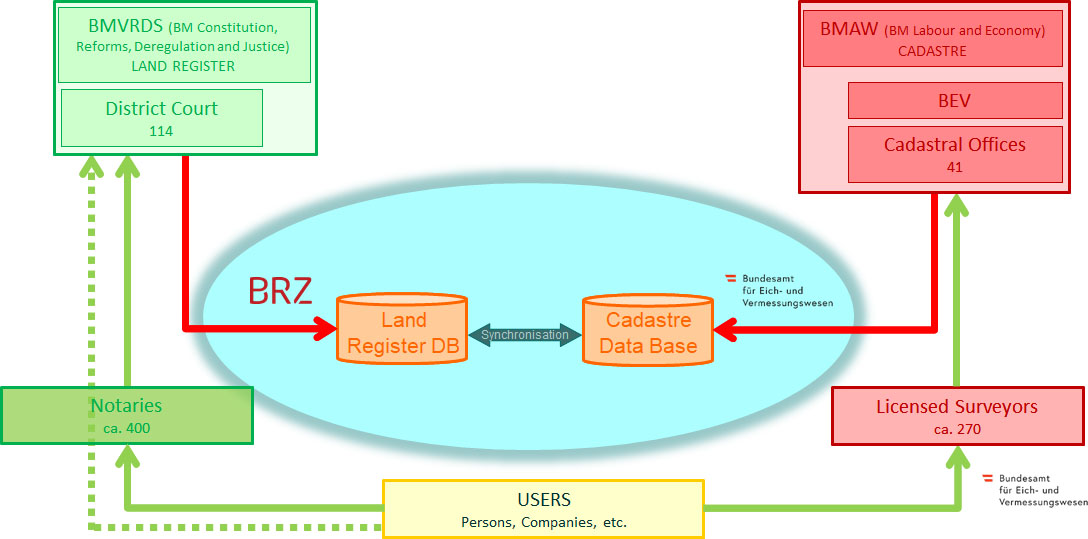
Figure 2.
Organization of Austrian LAS (adapted figure from source: BEV).
The Austrian LAS is characterized by the following principles:
-
Principle of registration: Acquisition, transfer, restriction and abrogation of rights can only be done by registration of deeds or rights (requirement: legal basis – ‘title’). Rights connected with land can be categorized into three types:
- a)
civil rights, which are only valid by registration (e.g. ownership);
- b)
civil rights, which are valid though they are not registered (as exception);
- c)
public rights, which are related with land and have an overall validity (e.g. protection of historical monuments or control points).
- a)
-
Principle of legality: Only rights, which are defined within the laws, can be established and stored in the LAS. This fact is the kernel of a title system like the Austrian one. The land register office has to check the validity of conditions. This check is restricted to potential obstacles based on either the actual status of the land register or on the documents to be registered. The reliability of documents forming the basis for the application to the land register is ensured by notaries.
-
Principle of application: Entries in the LAS are generally not made ex officio, but only by written request of right holders or beneficiaries of a legal change. However, there are exceptions where the principle of application is broken, such as in the case of official rectification of the land register from inadmissible or objectless entries. This principle plays a crucial role in maintaining the accuracy and reliability of the land register.
-
Principle of ranking: The rights are established in sequential order by a principle of ‘first come, first served’. This is done via a time stamp for all incoming applications within the diary. In case of a request for registration of excluding rights, the right of the applicant having applied first will be entered. For rights registered in a timely sequence (e.g. mortgages), the rights registered earlier have priority.
-
Principle of trust/confidence: The land register enjoys irrefutable presumption of correctness, i.e. everyone can rely on the accuracy and completeness of the register entries. A third party can count on the public register and effect his contracts on this basis. This principle can only be applied when the trust is worth protecting. Protection, therefore, will be extended to:
- o
a person who acquires the right by agreement;
- o
a person who acquires a property against a consideration (not as a gift);
- o
a person who acts “bona fide”.
The principle of confidence protects everyone who acquires a (property) right thus relying on the entries in the land register, even when the land register deviates from the actual (legal) status. In Austria, the state also guarantees parcel boundaries as soon as a parcel is surveyed in accordance with the surveying law in the legal cadastre (see Chapter “Legal Cadastre”).
- o
-
Principle of public access: Everybody has the right to view entries in the land register and the cadastre. There is open access to the information via web-based services. Expenses for such a service may be charged to the applicant.
-
Technical principles: Unique identifiers, positional reference, high geometric accuracy, security, documentation of changes, countrywide completeness, up-to-date data.
Outstanding Characteristics of the Austrian Cadastre
The information provided by the cadastre are data for identifying, addressing, and locating parcels and boundaries as well as data documenting land cover information. All data can be visualized geometrically as well as numerically.
Geometry
The geometry of the Austrian cadastre is characterized by its high accuracy and by its integration into the Austria’s national coordinate systems (MGI-Gauss-Krueger and ETRS 89). The coordinates of about 200,000 control points and their topographic sketches can be accessed via an online platform belonging to the BEV (see Figure 3). The points distributed throughout the country have an average density of almost three points per square kilometre, which is a sufficient basis for the integration of (boundary) surveys into the national reference frame.
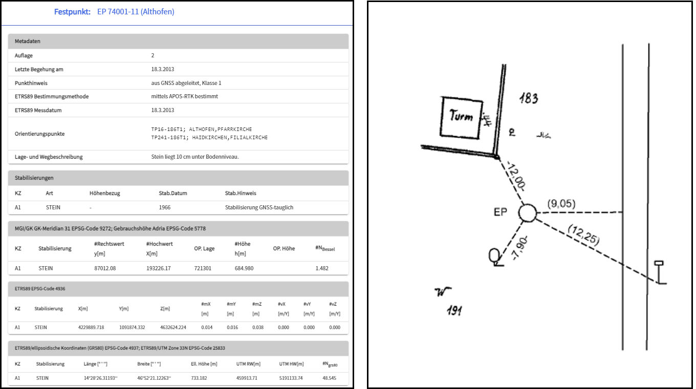
Figure 3.
Coordinates and Sketch of National Reference Point EP 74001-11 (Source: kataster.bev.gv.at).
The national reference frame in the MGI-Gauss-Krueger system has grown historically since 1862. It was created in several consolidation steps with the measurement and adjustment tools available at the time, resulting in high relative (local) accuracies of the frame and all boundary points. Today, the control points in ETRS 89 are measured with high precision and high absolute accuracy using GNSS methods. The ETRS 89 coordinates can be transformed into the MGI-Gauss-Krueger system using standard formulae. Compared to these transformed coordinates, the MGI-Gauss-Krueger coordinates measured since 1862 show deviations. The BEV has therefore developed a software (BEV-Transformator: https://transformator.bev.gv.at/at.gv.bev.transformator/) that enables the online calculation of local transformation parameters between the historical Gauss-Krueger coordinates, which are characterized by historical metrological deviations, and the ETRS 89 coordinates. This means that all boundary points of the digital cadastral map – in the historically grown MGI-Gauss-Krueger system – can be converted into ETRS 89 coordinates. Conversely, it is also possible to measure new boundary points with GNNS, as the ETRS 89 coordinates can also be adapted to the coordinates of the historically grown Gauss-Krueger system by means of local transformations.
Legal Cadastre
The ‘legal cadastre’ was introduced by the Surveying Act of 1969 to ensure the security of parcel boundaries. Since then, the parcels surveyed according to new geometric and legal guidelines are recognized as ‘legal cadastre parcels’ in the Austrian cadastre. In the legal cadastre, boundary lines are defined by the surveyed and mapped boundary points. This was a paradigm shift of the legal acceptance of boundary points from visible landmarks to abstract mathematical coordinates. For this purpose, the boundaries have to be defined clearly, the boundary lines have to be agreed verifiably by all owners of the neighbouring parcels, and the boundary points have to be surveyed accurately in the national reference system (Ernst et al. 2019). The legal cadastre is not a separate register, but part of the Austrian cadastral system characterized by the documented agreements of parcel boundaries by neighbours. To date, approximately 18% of all Austrian parcels – predominantly in built-up areas – meet the quality features of the legal cadastre.
They are labelled in the numeric system by the letter ‘G’ and in the cadastral map by a dotted line under the parcel number (see Figure 4).
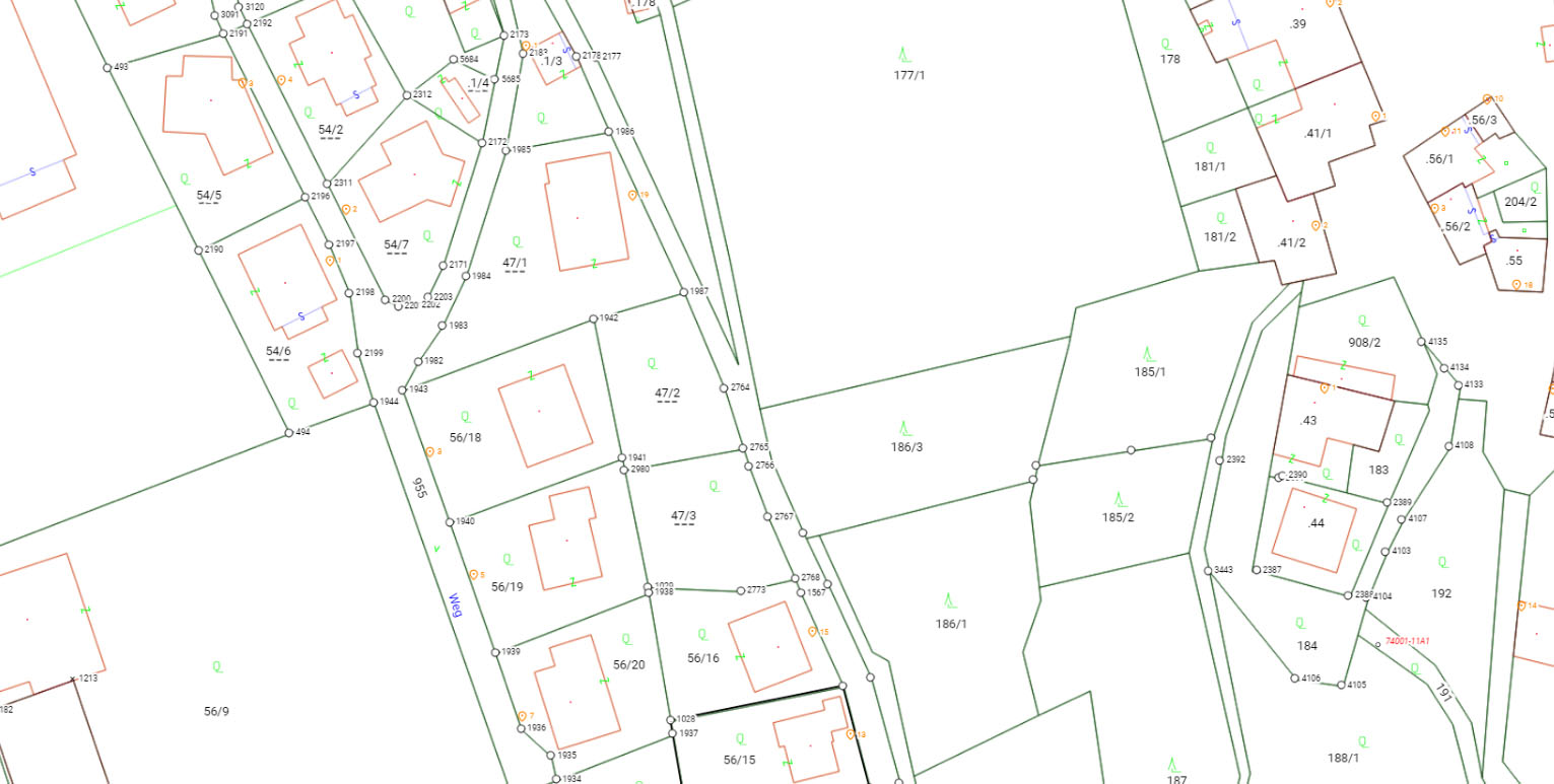
Figure 4.
Austrian Digital Cadastral Map (Source: www.kataster.bev.gv.at).
In case of boundary disputes, the cadastre authority can stake out the boundary of a parcel in the legal cadastre using known coordinates, and the owners do not have to go to court. In regions with ground movements (landslides), where the boundaries cannot be fixed through coordinates, parcels cannot be transformed to the legal cadastre. Currently, solutions for such situations are being discussed (Fink 2022; Weber et al. 2022).
The Relationship between BEV, Cadastral Offices and Licensed Surveyors
The process of establishing the legal cadastre involves the cadastral authority, represented through the BEV and the cadastral offices, as well as licensed surveyors and other qualified individuals as stipulated by the Real Estate Division Act (‘Liegenschaftsteilungsgesetz’). These licensed surveyors, who work privately, are primarily responsible for the surveying and subdivision of parcels according to the requirements of the owners and within the framework of land use planning. Transferring areas between parcels always requires a surveyor, who ensures that boundaries are fixed and confirmed by neighbours. Additionally, notaries – who operate privately but with public authorization – and attorneys support clients with property ownership transfers, inheritance matters, mortgage registrations, and other related legal rights and obligations. Changing the ownership of whole parcels does not require a surveying process.
Only licensed surveyors are entitled to perform cadastral tasks such as creating subdivision documents, which are essential for parcel subdivision and boundary point restoration (Abart et al. 2017). Any surveyor who intends to work on cadastral issues has to apply for a licence as a chartered engineering consultant for surveying at the Federal Chamber of Civil Engineers (Bundeskammer der ZiviltechnikerInnen).
Licences as a chartered engineer are granted to Austrian citizens or nationals of a member state of the European Union who have completed a master’s study program in geodesy and who have at least three years of practical experience in surveying (one of these in cadastral surveying). In addition, an examination has to be passed successfully on the following subjects: Austrian administrative law, business administration, legal and professional regulations relevant to surveying, and professional and ethic laws (https://www.arching.at/ziviltechnikerinnen/berufszugang.html).
The Federal Chamber of Civil Engineers as well as the professional subunits and the regional entities are public bodies and the statutory professional representation of state-authorized and certified technical consultants (architects and consulting engineers with various authorizations for e.g. technical, scientific, mining, and agricultural disciplines). There are about 300 chartered engineering consultants for surveying registered in Austria, and all of them are mandatory members of the chamber. It is the duty of the chamber to represent and promote the professional, social, and economic interests of the technical consultants and to monitor fulfilment of the professional obligations of the technical consultants.
Digital Processes between Licensed Surveyors and Cadastral Offices – Dual System
The cadastre and land registry spent several decades focussing on digitizing all the data, including historical documents. Currently the focus is on improving the processes between the various stakeholders that contribute to the LAS.
Since 2012, licensed surveyors have submitted all applications digitally. The shift to electronic legal transactions between the private sector, such as notaries, surveyors with cadastre authorities and land register authorities, has significantly accelerated registration processes. The transfer of paper documents between stakeholders took more than a week; this has now been shortened to less than a day. Updating cadastral information starts with a review of the related surveying documents, the determination of boundaries, the consent of neighbours to the plot layout, and the requirements regarding land use planning. Changes in the cadastre based on these documents are promptly initiated, almost simultaneously with the transmission of information on the decision by the land register via the electronic interface. Due to the right of stakeholders to challenge the registered property rights within 30 days, legal validity may be delayed.
In 2018 the introduction of the ‘structured surveying document’ (‘Strukturierter Plan’) enabled a significant advancement towards fully digitalizing the workflow of surveying management processes (Klotz 2018). Surveyors now submit these documents for the direct transfer of all changes, such as the subdivision table (see Figure 5), owner details, and coordinates into the cadastral system.
With this ‘structured submission of documents’ it is now possible to introduce structured text data in the form of signed PDFs suitable for long-term archiving and thus create a continuous digital data flow from the surveyor to the cadastral register of the BEV. The data read from the PDFs is transferred to the BEV’s cadastral management system.
The structured submission of surveying plans facilitates an automated pre-check service. This check enables the surveyor to comprehensively check the formal correctness of his document and the correctness of his data in comparison to the legal status of the cadastre.
The subdivision table is pivotal in the interconnected administrative procedures involving both the cadastral authority and the land register, as it serves as an essential reference and streamlines the entire process of property change between all involved stakeholders, such as notaries, judicial officers at the land registry courts, and staff at the cadastral offices.

Figure 5.
Subdivision Table (Source: BEV).
This innovation improves data quality and speeds up the verification process in cadastral offices. Financial incentives and reduced fees encourage surveyors to adopt this new method.
Availability of Cadastre Information
The Austrian cadastre and land registry system has evolved into an effective tool for depicting and delineating areas, along with their associated rights and obligations. These systems are safeguarded under constitutional law. The operational procedure encompasses boundary negotiation, on-site demarcation, cartographic representation, consensus-based contracting, and the archiving of all relevant documents by legally authorized bodies. The relevant data and digital records are stored in databases that are accessible to the public. However, searches by name are limited to ensure the protection of personal data.
The BEV and the land register authorities provide all the geometric and physical information of the cadastre, the names of owners of parcels, and all the land rights online for the public. In general, a small fee is required for this information. A special cadastral service also provides access to the cadastral information free of charge (www.kataster.bev.gv.at).
These databases offer 24/7 access to the public and include WebMap Services, facilitating the easy and continuous availability of information.
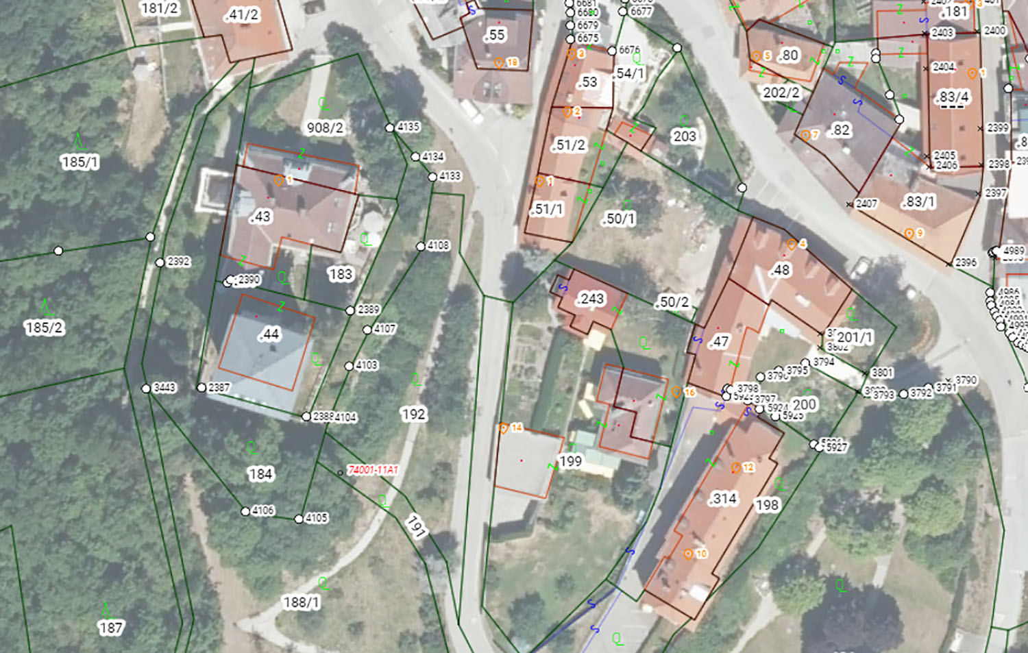
Figure 6.
Cadastral Map Overlaid to Orthophoto (Source: www.kataster.bev.gv.at).
Summary and Outlook
For over two hundred years the Austrian cadastre has been a success story marked by numerous innovations that have enhanced the quality of the cadastral system, streamlined the efficiency of institutions involved, digitized the processes and made access to all products easier and cheaper for the general public.
The Austrian cadastre is an important basis for all geodata in Austria, and it achieves important features, such as flexibility in the spatial data capture approaches, countrywide availability and completeness, participative approaches, as well as feasibility of use for both the government and for society.
Modern land administration systems also provide information about the value of land. This is only partially the case in Austria (Wessely et al. 2015). Therefore, innovations for the further development of the cadastre will also be necessary in the coming years (Unger et al. 2017, Unger et al. 2022).
References
-
Abart, G;Ernst, J;Twaroch, C.2017.
“Der Grenzkataster – Grundlagen, Verfahren und Anwendungen”
. 234S. Neuer Wissenschaftlicher Verlag
,Wien
; ISBN 9783708311401. -
Bundesamt für Eich- und Vermessungswesen. 2023.
“Geschichte, Innovation und Fortschritt für die österreichische Gesellschaft – 100 Jahre BEV 1923 – 2023”
.Bundesamt für Eich- und Vermessungswesen
.Wien
. -
Ernst, J;Mansberger, R;Muggenhuber, G;Twaroch, C;Wessely, R.2017. “Österreichische Beiträge zum Kataster im internationalen Umfeld”. In:
Bundesamt für Eich- und Vermessungswesen, 200 Jahre Kataster – Österreichisches Kulturgut
, 238–294;Bundesamt für Eich- und Vermessungswesen
,Wien
. -
Ernst, J;Mansberger, R;Muggenhuber, G;Navratil, G;Ozlberger, S;Twaroch, C.2019. “The Legal Boundary Cadastre in Austria: A Success Story?”.
Geodetski Vestnik
. 2019; 63(2): 234–24. https://doi.org/10.15292/geodetski-vestnik.2019.02.234-249 -
Fink, G.2022.
“Erstellung eines Leitfadens für Vermessungen in Gebieten mit Bodenbewegungen”
. Master Thesis,TU Wien
. https://doi.org/10.34726/hss.2022.97641 -
Hernik, J;Prus, B;Dixon-Gough, R;Taszakowski, J;Navratil, G;Mansberger, R.2020. “The Evolution of Cadastral Systems in Austria and Galicia (Poland): Different Approaches to a Similar System from a Common Beginning”.
The Cartographic Journal
. 2020; 57(2): 97–112. https://doi.org/10.1080/00087041.2018.1534344 -
Klotz, S.2018. “Strukturierter Plan – automatisierte Datenübernahme aus PDF-Urkunden, ein weiterer Schritt zur Digitalisierung des Katasterführungsprozesses”.
Österreichische Zeitschrift für Vermessung und Geoinformation (VGI)
, Heft 1, 21–25; ISSN 1605–1653. -
Mansberger, R;Ernst, J;Navratil, G;Twaroch, C.2016: “Kataster E³ – Entstehung, Evidenzhaltung und Entwicklung des Franziszeischen Katasters”.
Österreichische Zeitschrift für Vermessung und Geoinformation (VGI)
, Heft 4, 178–176; ISSN 1605-1653. -
Mattsson, H;Mansberger, R; 2017. “Land Governance / Management Systems.” In “Land Ownership and Land Use Development”,
edited by
Hepperle, H;Dixon-Gough, R;Mansberger, R;Paulsson, J;Hernik, J;Kalbro, T.371.Zurich
:vdf Hochschulverlag AG
. https://doi.org/10.3218/3804-0 -
Muggenhuber, G.;Navratil, G.,Twaroch, C.;Mansberger, R.2011: “Development and Potential for Improvements of the Austrian Land Administration System.” In
“FIG Working Week 2011 – Bridging the Gap between Cultures”
.FIG
. 15 p. -
Muggenhuber, G.;Wessely, R.;Navratil, G.;Twaroch, C.;Unger, E.-M.;Mansberger, R.2017. “Die Entwicklung des Katasters – genutzte Potentiale und künftige Innovationen”.
Österreichische Zeitschrift für Vermessung und Geoinformation (VGI)
, Heft 1, 16–23; ISSN 1605-1653. -
Twaroch, C;Hiermanseder, M;Mansberger, R;Navratil, G.2016. “Der Weg zum Grundsteuerpatent”.
Österreichische Zeitschrift für Vermessung und Geoinformation (VGI)
, Heft 3, 118–127; ISSN 1605-1653. -
Unger, E;Steudler, D;Navratil, G;Muggenhuber, G;Mansberger, R;Twaroch, C.2017. “Das (österreichische) Landadministrationssystem der Zukunft? Visionen eines zukünftigen Katasters”.
Österreichische Zeitschrift für Vermessung und Geoinformation (VGI)
, Heft 3, 174–183; ISSN 1605-1653. -
Unger, E;Wessely, R;Mansberger, R;Muggenhuber, G;Navratil, G;Twaroch, C.2022. “Whose Land? Whose Data about Land? Betrachtungen zum österreichischen Landadministrations-System”.
Österreichische Zeitschrift für Vermessung und Geoinformation (VGI)
, Heft 2, 78–89; ISSN 1605-1653. -
Weber, V.;Navratil, G.;Blauensteiner, F.2022. “Managing Inhomogeneity in the Control Point Network during Staking Out Cadastral Boundaries in Austria”.
ISPRS International Journal of Geo-Information
, 11(5); ISSN 2220-9964. https://doi.org/10.3390/ijgi11050274 -
Wessely, R;Navratil, G;Mansberger, R;Unger, E.2015. “Ein mögliches Massenbewertungssystem von Liegenschaften in Österreich auf Basis bewährter internationaler Anwendungen”. In:Twaroch, C;Wessely, R(
Hrsg.
).“Liegenschaft und Wert – Geodaten als Grundlage einer Liegenschafts-bewertung”
, 191–205;Neuer Wissenschaftlicher Verlag
,Wien
; ISBN 978-3-7083-1023-7.