Swiss Cadastral System – Strong Involvement of Private Sector
PhD.
Former Scientific Associate at Federal Office for Topography swisstopo (1991–2023)
Lecturer at ETH Zurich (2006–2021)
Daniel Steudler holds a PhD degree from the University of Melbourne, Australia and was a scientific associate with the Swiss Federal Directorate for Cadastral Surveying until the end of 2023. He was active in FIG Commission 7 for many years and was chair of the FIG Task Force on “Spatially Enabled Society”. He published widely in the cadastral field and consulted internationally in land administration and cadastral issues. From 2015–2023 he was chair of the EuroGeographics “Cadastre and Land Registry” Knowledge Exchange Network.
Publisert 27.08.2024, Kart og Plan 2024/2, Årgang 117, side 199-205
The Swiss land registration system along with the cadastral system was established in 1912 with the introduction of the Civil Code arranging private-law rights. The legal purpose of the cadastral data was extended with the introduction of the digital format in 1993 and cadastral data henceforth also serve as the basis for other land information systems. Ever since its beginnings in 1912, the Swiss cadastral surveying system has been operated on the basis of the licensing of cadastral surveyors; only licensed land surveyors can carry out cadastral surveying. Although they mostly operate in the private sector, they are public agents, bound by regulations and contracts.
Keywords
- Cadastral surveying system in Switzerland ,
- digital format ,
- licence and accreditation
Introduction
The Swiss land registration system along with the cadastral system was established in 1912 with the introduction of the Civil Code arranging private-law rights. The aim of the legislation behind the land registration and cadastral system was to provide and guarantee security of landownership. The land register consists of five components, which are the main register (one page per land parcel), the logbook, the cadastral maps based on cadastral surveying (providing the accurate location and size of land parcels), the auxiliary registers (ownership register, creditors register), and the receipts (cadastre.ch, 2024a).
Cadastral Surveying System
History
During the early nineteenth century, under Napoleonic influence, cadastres were established in many of the 26 cantons; this was, however, mainly for fiscal purposes. With the entering into force of the federal constitution in 1847, a modern state with a stable rule of law developed. With industrial development, the need for a legal cadastre emerged, i.e. securing land ownership rights and enabling land transactions. The Civil Law from 1912 constitutes the basis of the cadastral system with the two main elements of land registration and cadastral surveying. Several principles were defined at that time, and they remain valid today:
-
the land register consists of five components, one of which is spatial description by the cadastral map;
-
the cadastral map has to be based on cadastral surveying;
-
according to the political and administrative structure of the country, the operational control of cadastral surveying and land registration rests with the cantons;
-
the confederation supervises and subsidizes the cantons;
-
cadastral surveying can be – and mostly is – contracted out to private sector land surveyors;
-
surveyors who carry out cadastral surveying need to hold a federal licence.
Institutional Framework
According to the decentralized political and administrative structure of Switzerland, the organizations involved in the cadastre are situated on different administrative levels – federal and cantonal – and have different tasks and functions. For cadastral surveying, the Federal Directorate for Cadastral Surveying has the main responsibility of supervising the cantonal surveying agencies. The cantonal agencies themselves have the responsibility of implementing cadastral surveying within their jurisdiction and territory. There are different, although similar solutions in each canton, but most of them contract the fieldwork as well as the maintenance of surveying data and cadastral maps out to private land surveyor offices, which then act as public agents on behalf of the cantons. On the federal level, approximately eight employees work on cadastral surveying, approximately 200 work on the cantonal level with approximately another 2,500 in the private sector and municipalities (compare also Figure 1, as well as Figures 4 and 5).
Private Sector Involvement
The involvement of the private sector in cadastral surveying has been normal practice since the establishment of the cadastral system in the early 1900s; it carries out 80–90% of the total work. Through a tendering process, the private sector is commissioned with projects for data acquisition, upgrading, and updating. There is a long-established and accepted system through which the private sector is mandated with data-updating and maintenance procedures. As such, the private surveyors act as public agents providing decentralized services close to customers. With the availability of digital data, the cantons and municipalities are introducing their own land information systems, while private surveying offices quite often support such projects either by contract or by consulting.
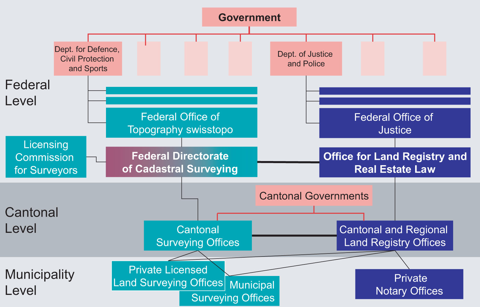
Figure 1.
Organizations Involved in the Swiss Cadastral System.
For land registration, the regulations, the set-up of offices and districts, and the appointment and compensation of land registrars fall under in the competence of the cantons. The confederation supervises the cantons through the “Federal Office of Land Registration and Land Law” with approximately five employees. Some of the smaller cantons maintain a single cantonal land registry office, while in 18 cantons there are offices for each or several districts, or even for each municipality, resulting in a total of approximately 350 cantonal or regional land registry offices.
Introduction of Digital Format
From 1912 until 1993 the cadastral system had a purely legal purpose and was mainly geared for securing land ownership rights. The cadastral surveying data have, however, always been widely used as basis for utility mapping and all sorts of municipal and planning and management purposes as well. With the introduction of the digital format in 1993, cadastral surveying data were henceforth also employed to serve as basis for other land information systems.
There is only one comprehensive cadastral system, which covers the whole territory in a complete way. Every piece of land is a parcel with an assigned public or private owner. Roads or public areas are also considered to be parcels and can, for example, be owned by municipalities, cantons, or federal organizations. Private companies or cooperatives can also be owners of land parcels.
The land registration system is based on a folio principle, i.e. each “land parcel” on the ground is related to exactly one land ownership title registered in the land registry. Every land parcel has a unique parcel identifier number to which all parcel-relevant information can be linked. Buildings are by definition integral parts of “land parcels” and by default cannot cross parcel boundaries. In the case of a building sitting on top of a parcel boundary, the boundary would need to be rectified accordingly or the two parcels would need to be merged. Land parcels can be sold only as complete entities.
A group of experts – consisting of representatives from the Federal and cantonal levels, as well as the private sector – developed the basics for the introduction of the digital format in cadastral surveying, taking into account the above-mentioned elements and requirements. The result was the introduction of two new ordinances in 1993: VAV (“Verordnung für die Amtliche Vermessung” or Ordinance for Cadastral Surveying) and TVAV (“Technische Verordnung für die Amtliche Vermessung” or Technical Ordinance for Cadastral Surveying), which replaced the old instruction for cadastral surveying from 1919. The aim was to renovate the cadastral surveying system and introduce the digital data format. Due to the versatility of data in digital form, the purpose of the cadastral surveying data has been extended from purely serving the land register to serving land information systems of any kind. The establishment of the system-independent data description language INTERLIS was a crucial element in this concept.
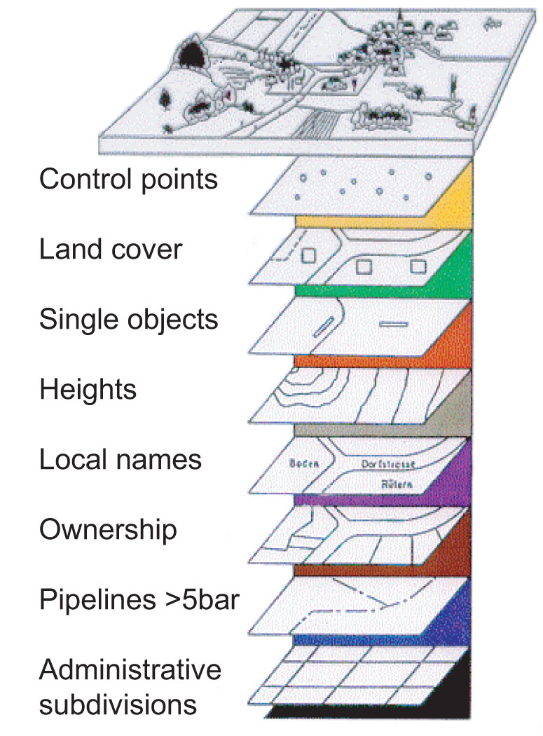
Figure 2.
The Original Eight Information Layers of Digital Swiss Cadastral Maps (adapted to 11 layers in 2004 and currently under revision).
The “digital” cadastral map was originally defined to consist of eight information layers, as illustrated in Figure 2. By definition, the two layers “Land cover” and “Ownership” cover the whole territory in a complete way, i.e. without overlaps and gaps, while other layers have different structural definitions. Buildings are part of the “land cover” layer. The separation of the data into the eight information layers has the advantage that the layers can be acquired independently from each other. Each of the eight information layers is object-oriented and defined by an entity-relationship diagram, which is the data model and also the basis for the translation of the data into an interoperable INTERLIS data exchange format.
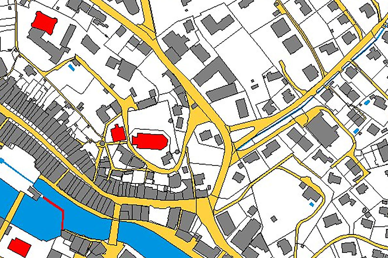
Figure 3.
Example of Digital Swiss Cadastral Map with Object-oriented Approach.
The introduction of the digital data-modelling concept for the description of cadastral surveying data in 1993 triggered the development of spatial data infrastructures (SDIs) in Switzerland. The basic element is the data description language INTERLIS with which spatial data can be defined, modelled, and exchanged without information loss and independent from any system restrictions. The data model for cadastral surveying was named AV93, which is defined in the federal TVAV ordinance and legally binding for cadastral surveying in all cantons. The data-modelling concept with INTERLIS has initiated the definition of more than 100 other spatial data domains since 1995, enabling the use of the same data exchange mechanisms as in cadastral surveying. In 1998, a new coordinating body (COSIG) was established to foster the coordination, acquisition, and use of spatial data within the federal administration. COSIG promotes the INTERLIS concept for the definition and handling of all spatial data.
Licensing and Accreditation for Cadastral Land Surveyors
With the introduction of the land registration system in 1912, the confederation also introduced regulations for the licensing of cadastral surveyors; only licensed land surveyors can carry out cadastral surveying. Although they mostly operate in the private sector, they are public agents, bound by regulations and contracts.
State Examination and Licence
In order to become active in cadastral surveying in Switzerland, it is mandatory to have passed the Federal state examination for cadastral surveying. These examinations are organized by the Cadastral Surveying Commission supported by the Federal Directorate for Cadastral Surveying. According to its official website (cadastre.ch, 2024b), there are three conditions that have to be met for admission to the examinations: recognized university Master’s degree; sufficient theoretical training; and at least two years of appropriate professional experience.
The state examination is practice-oriented and covers four subject areas: geomatics, cadastral surveying, land management, and corporate management. The state examination is carried out once a year; it lasts approximately 10 days and is carried out in practical, written, as well as oral form.
Accreditation and Proportions
Once the candidate has passed the state examination and thus earned the licence, he or she also has to register in the Register of Cadastral Land Surveyors in order to be allowed to carry out work in cadastral surveying. Every person entered in the register agrees to comply with the professional rules and obligations. With this, the technical qualification of cadastral land surveyors is secured and also expanded to include personal qualifications. The legislation thus aims to ensure that government services are provided by highly qualified specialists.
The statistics of the Federal Directorate for Cadastral Surveying (Steudler, 2023) show that by the end of 2022 there were a total of 2,867 persons active in the Swiss cadastral surveying systems. Of those, 6.6% were working in public administration on the federal or cantonal levels; another 6.6% were employed in municipal public administrations (mainly in 11 larger cities), and the remaining 86.8% in private surveying offices. This illustrates the strong involvement of the private sector, while the public sector is still responsible for the legislative part of cadastral surveying. With this, the cadastral surveying system has been successful in keeping the quota of state employed personnel at a rather low level (Figure 4).
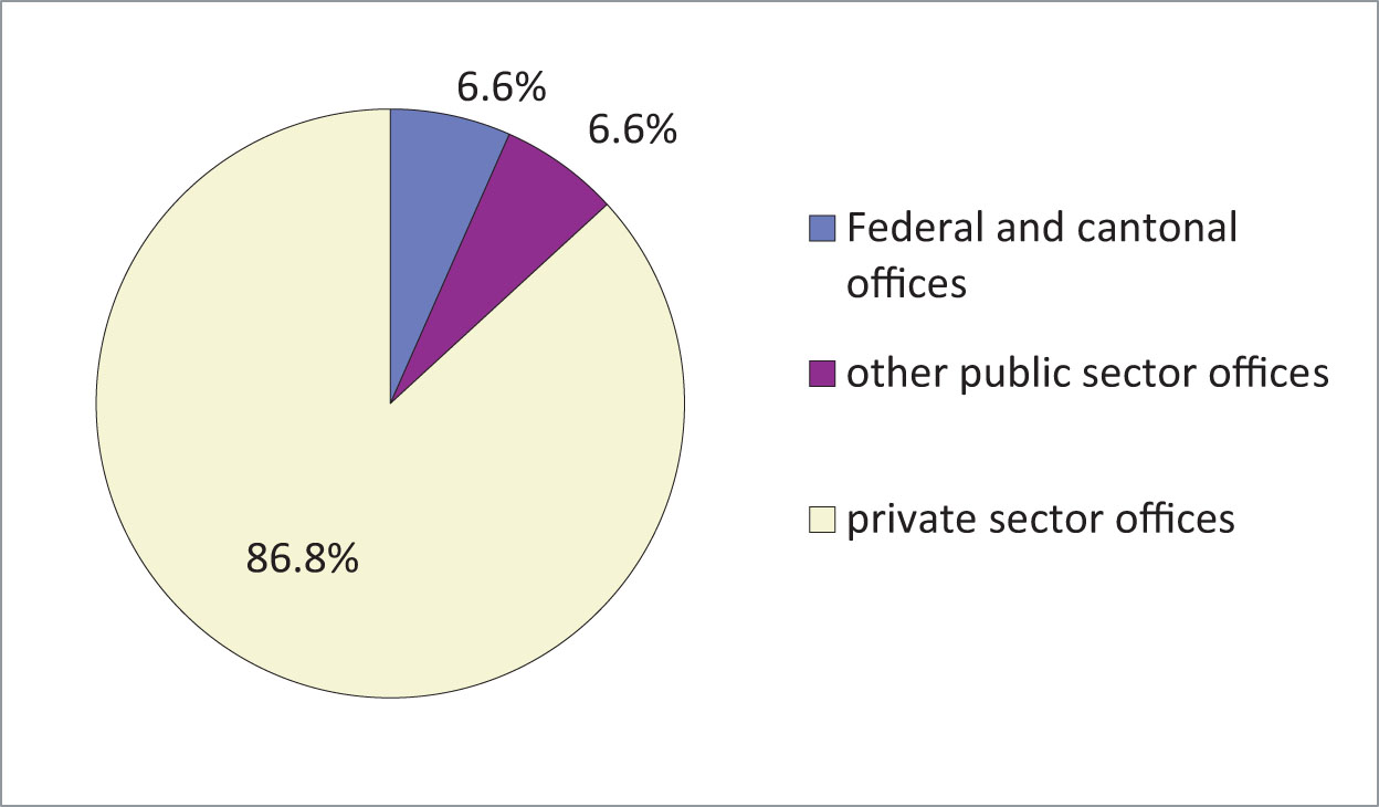
Figure 4.
Proportions of People Active in Public and Private Sectors (at the end of 2022) (Steudler, 2023).
Of the 2,867 persons, 11.5% held the licence and accreditation in the register, as illustrated in Figure 5.
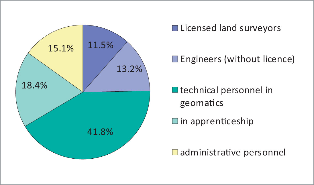
Figure 5.
Proportions of Personnel Active in Cadastral Surveying (at the end of 2022) (Steudler, 2023).
Features of the Licensing System
In an expert report, Carosio and Nef (2005) pointed out several features that define the context of the Swiss licensing system for cadastral land surveyors:
-
the delegation of public sovereign tasks to private individuals;
-
expansion of the purpose of cadastral surveying as a basis for the development and operation of any land information system;
-
low state quota and minimal human and financial burdens on the state;
-
outsourcing of sovereign tasks through submission procedures;
-
the same level of education and training for cadastral land surveyors employed by the federal government, cantons, municipalities, and for private sector surveyors;
-
close interaction and cooperation between cadastral surveying and land registration.
Carosio and Nef (2005) conclude that the cadastral land surveyors licence forms a necessary core element of the organization of cadastral surveying in Switzerland. It is a link in a chain of legal and organizational requirements to ensure high-quality official surveying. The licence provides quality assurance and guarantees professional responsibility regardless of the organizational and legal structure of the public or private surveying offices involved. The granting of the licence requires professional and solid training and practice in all four subject areas of the state examination (as mentioned above in section “State Examination and Licence”).
Conclusions
The Swiss cadastral system is operated in a highly federal context with 26 cantons. The strong involvement of the private sector ensures that innovation is adapted on a continuous basis, while the licensing and accreditation system provides quality assurance and a guarantee of professional responsibility.
References
-
cadastre.ch (2024a).
Web information
at <https://www.cadastre.ch/en/gb/objective.html>, accessed on 8 Feb. 2024. -
cadastre.ch (2024b).
Web information
at <https://www.cadastre.ch/de/about/education/patent.html>, accessed on 8 Feb. 2024. -
Carosio, A.andU.C. Nef(2005).
Gutachten über die Bedeutung und Notwendigkeit des Eidgenössischen Patents für Ingenieur-Geometerinnen und Ingenieur-Geometer, vom 24.8.2005 im Auftrag des Schweizerischen Bundesrates
, 34 p, available inGerman and French
. -
Steudler, D.(2023). Monitoring des volkswirtschaftlichen Nutzens der Daten der amtlichen Vermessung 2022,
cadastre
No. 43, p. 14–15, Dec. 2023, <https://www.cadastre.ch/de/services/revue.detail.publication.html/cadastre-internet/de/publications/revue/cadastre-43-2023-dt.pdf.html>, accessed on 6 Feb. 2024.